Precision Land Surveying & Engineering Solutions You Can Trust

Delivering accurate, reliable, and technology-driven surveying, engineering, and geospatial services for infrastructure, real estate, and development projects across India.

Who We Are

About EAGLES EYE ENGINEERS LLP

EAGLES EYE ENGINEERS LLP is a professional firm specializing in land surveying, civil engineering, and geospatial technology services. We support clients at every stage of project development—right from land assessment and planning to execution and compliance.

With a strong focus on accuracy, innovation, and ethical practices, we help eliminate project risks, prevent costly errors, and ensure smooth execution. Our approach is data-driven, technology-enabled, and outcome-oriented.

We don’t just deliver reports—we deliver confidence.

Our Mission

To provide unparalleled land surveying and engineering services with integrity, efficiency, and the highest standards of accuracy—empowering our clients to execute projects successfully and compliantly.

Core Values 

🎯 Accuracy without compromise

🤝 Integrity & transparency

⚙️ Engineering excellence

🚀 Innovation through technology

⏱ On-time, reliable delivery

Our Services

Surveying Services

  • Boundary & Property Surveys
  • Topographic Surveys
  • ALTA / NSPS Land Title Surveys
  • Construction Staking & Layout
  • Subdivision Planning & Platting
  • Drone & LiDAR Unmanned Surveys
  • GPR (Ground Penetrating Radar) Surveys
  • Hydrographic & Bathymetric Surveys
  • Soil Investigation & Analysis

Engineering Services

  • Detailed Project Reports (DPR)
  • Project Planning & Feasibility Studies
  • Geometric & Alignment Designs
  • Site Development Planning
  • Infrastructure & Utility Design
  • Drainage & Stormwater Management
  • Roadway & Transportation Engineering
  • Environmental & Regulatory Compliance

Geospatial Technology Services

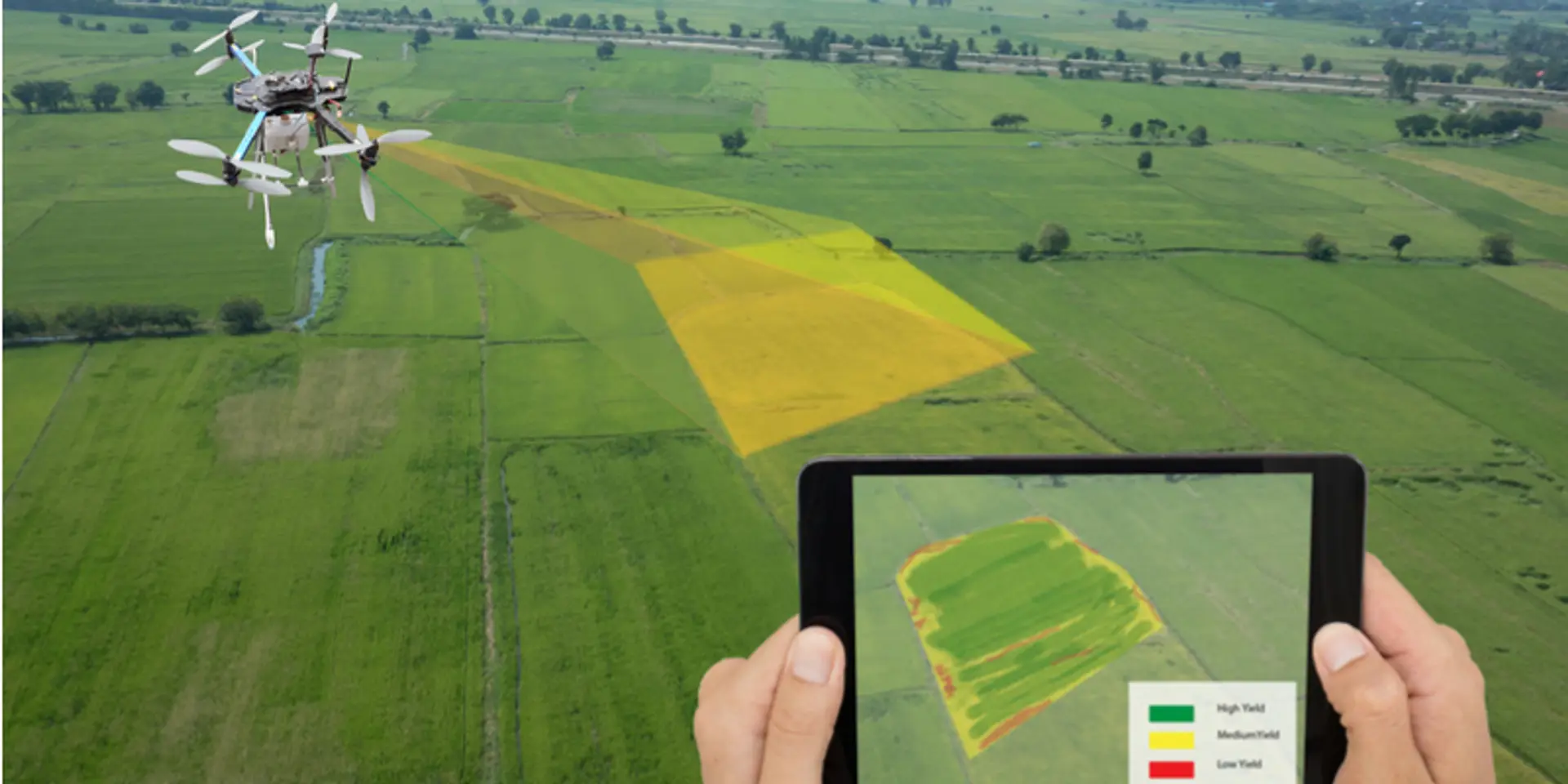
Advanced spatial data for smarter planning and faster decision-making.

  • GIS Mapping & Spatial Analysis
  • Remote Sensing Solutions
  • High-Accuracy GPS Services
  • 3D Laser Scanning & Modeling

Why Choose Us?

We combine technical expertise with modern technology to deliver outputs that stand up to legal, engineering, and execution scrutiny.

Our Expert Team

Our team comprises licensed land surveyors, civil engineers, and geospatial specialists with extensive experience across diverse project environments.

Every project undergoes internal technical review to ensure accuracy, compliance, and attention to detail. Our professionals work closely with clients, consultants, and authorities—ensuring seamless coordination and clarity at every step.

Commitment to Quality & Accuracy

Accuracy is the foundation of everything we do. Our quality assurance framework includes:

  • Multi-level data verification

  • Instrument calibration & validation

  • Industry best-practice adherence

  • Advanced software & automation tools

This ensures our deliverables are precise, reliable, and audit-ready.

Industries We Serve

  • Real Estate & Land Development

  • Construction & Infrastructure

  • Government & Public Authorities

  • Environmental & Urban Planning

  • Transportation & Utilities

From small land parcels to large-scale infrastructure projects, we deliver with the same level of precision and accountability.

Technology-Driven Excellence

We continuously invest in advanced surveying instruments, drones, LiDAR systems, GIS platforms, and 3D scanning technologies. This allows us to deliver faster turnarounds, higher accuracy, and superior project insights.

Innovation isn’t optional—it’s our operating standard.

Get In Touch

Ready to Start Your Project with Confidence?

Address

54, Bismillah Building, Ranade Road, Dadar West – 400014

Email Support

eagleseyeengineers9@gmail.com

Latest Blogs